سعر فوب
أحصل على آخر سعر( Negotiable )
|1 Set Minimum Order
بلد:
China
نموذج رقم:
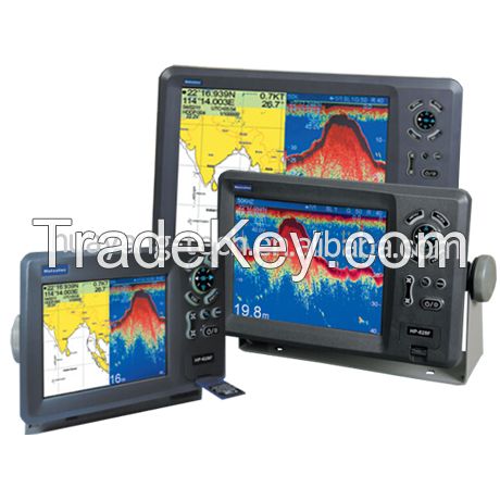
HP-628F/HP-828F/HP-1228F
سعر فوب:
( Negotiable ) أحصل على آخر سعر
الموقع:
-
سعر الحد الأدنى للطلب:
-
الحد الأدني للطلب:
1 Set
تفاصيل التغليف:
carton
موعد التسليم:
within 1-3 days
القدرة على التوريد:
300 Set per Month
نوع الدفع:
T/T, Western Union
مجموعة المنتج :
الشخص الذي يمكن الاتصال به Ms. susan
29F East Tower Fuhua Road Futian Disrict, Shenzhen, Guangdong
High quality fish finder GPS chartplotter, boat gps and fish finder, boat GPS, marine fishfinder/GPS, fish finder GPS, marine GPS depth sounder, fishing GPS, marine GPS fishfinders
Matsutec
MODEL: KP***8F KP***8F KP****8F
COLOR LCD GPS Plotter combo with Fish finder
FEATURE:
1 High Resolution
1) KP***8F: 5.6 inches Color TFT Display, **0***0 pixels
2) KP***8F: 8 inches Color TFT Display, **0***0 pixels
3) KP****8F: *2 inches Color TFT Display, **0***0 pixels
2. 8 Color or 8 Level Amber Presentation
3. *0/**0 KHz Transceivers, Output Power:
1) KP***8F **0 Watt
2) KP***8F **0 Watt
3) KP****8F **0 Watt
4. Blue, Light Blue, or Black Background Color
5. 8 Range Scales, from ***5 to *****0 Feet
1) HP***8F from ***0m to ****0m
(Max: ***0ft, **0f, **0pB)
2) HP***8F from ***0m to *****0m
(Max: ***0ft, **0f, **0pB)
3) HP****8F from ***0m to *****0m
(Max: ***0ft, **0f, **0pB)
6. Range Offset to ****0 meters
7. Automatic Range and Grain Selection Mode
8. A-Scope Display for Rapid Fish ID and Detection
9. Multiple Display Modes:
-Single or Dual Frequency
-Bottom Zoom
-Bottom Lock Expansion
-Maker Zoom
-Navigation Data Screen
-A-Scope
*0. Digital Display of Speed, Depth, Water Temp and Position
*1. Adjustable Bottom or Fish Alarm
*2. Calibration in Feet, Fathoms or Meters
*3. Built-in Picture Simulator
*4. SD-cards slot for C-Map and user data
*5. C-Map MAX and K-Chart Selectable
*6. Tide table and Celestial
*7. Versatile Display Mode Include
-Plotter Screen
-Plotter + Sounder
-Sounder
-Nav.Data
-Satellite Information
-AIS Display
-Compass Screen
-Wind Screen
*8. GOTO track navigation
*9. MAP orientation select
*0. Proximity waypoints alarms
*1. Perspective View
*2. MAP Palette
-Normal
-Daylight exposed to sunlight
-Night in dark environment
-NOAA paper chart colors
SPECIFICATION
PLOTTER CHARACTERISTICS
1. Waypoints/Icons: *4,**0 waypoints with name, symbol, *0 proximity waypoint.
2. Route Memory: waypoint up to **9 points each, plus MOB and Track Navigator or Goto Track modes
3. Tracks: *1,**0 points automatic track log; *5 saved track (up to ***0 track points each) Let you retrace your path in both directions
4. Alarm: XTE, Anchor Drag, Arrival, Speed, Voltage, Proximity, Waypoint and Time, AIS alarm.
5. Palette
- Normal
- Daylight: Exposed to sunlight
- Night: In dark environment
- NOAA Paper chart color
6. Tides: Tide Data
7. Projection: Mercator projection
8. Position format: Lat/Lon
9. Base Map: Built-in ONWA K-Chart
*0. External Map: SD cards slot for user settings
*1. User data storage: Internal backup of user settings, or external SD-card
*2. Plot Interval: 1s to *9h or 0.*1nm to 9.*9nm
*3. Polotting scales: 0.*1nm to 1,**0nm
*4. Nav Data Input/Output:
- Input:
$*-BWC, $*-BWR, $*-DBT, $*-DPT, $*-GGA, $*-GLL, $*-HDG, $*-HDM, $*-HDT, $*-MDA, $*-MTW, $*-RMA, $*-RMB, $*-RMC, $*-TLL, $*-TTM, $*-VDR, $*-VHW, $*-VTG, $*-WPL, $*-ZDA
- Output:
$*-AAM, $*-APB, $*-BOD, $*-BWC, $*-GGA, $*-GLL, $*-RMB, $*-RMC, $*-VTG, $*-XTE, $*-ZDA
- Output for autopilot:
$*-AAM, $*-APB, $*-BOD, $*-VTG, $*-DBT, $*-DPT
*5. PERSPECTIVE VIEW: On/off
| بلد: | China |
| نموذج رقم: | HP-628F/HP-828F/HP-1228F |
| سعر فوب: | ( Negotiable ) أحصل على آخر سعر |
| الموقع: | - |
| سعر الحد الأدنى للطلب: | - |
| الحد الأدني للطلب: | 1 Set |
| تفاصيل التغليف: | carton |
| موعد التسليم: | within 1-3 days |
| القدرة على التوريد: | 300 Set per Month |
| نوع الدفع: | T/T, Western Union |
| مجموعة المنتج : | GPS chartplotter |


