Ukraine Ukraine
الشخص الذي يمكن الاتصال به Yura
عنوان Ukraine
اتصل الآن قيّم هذه الشركة اخبرنا عن البريد غير المرغوب فيه 360° Virtual Tours - 3D Visualization
 3D Animation - 3D Visualization
 3d animation-architecture design service-3d rendering
 3D animation-Exterior Renderings-3D architectural rendering
 3d architectural rendering
 3d architectural rendering walkthrough animation
 3D architectural rendering-Bird view and eye level view rendering
 3D architectural rendering-house design service
 3D Architecturual visualization-3D rendering
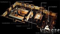 3D Floor Plans - 3D Visualization
Ukrainian Geodetic Company
| نوع النشاط | Business Services |
| الموقع الإلكتروني | https://123.net.ua/ |
| سنة التأسيس | 2003 |
| عدد موظفي الشركة | 26-50 |
| أسواق رئيسية | Europe |
| الشركة منتجات / خدمات | geodesy - design, consulting, geodesy, topographic plans, terrain surveys for topography, and terrain plans |
| مصنع الموقع | Ukraine |
| حجم المصنع | 5000 sqm to 10000 sqm |
| عدد خطوط الإنتاج | 0 |
| إجمالي حجم المشتريات السنوي | 2.5 - 10 Million USD |
| عدد من R & D الموظفين | 41 - 50 people |
| مراقبة الجودة | No |
| شهادة | N/A |
| عقد تصنيع | N/A |
| رأس مال مسجل | 1 - 2.5 Million USD |
| نوع الملكية | LLC (Limited Liability Corp) |
| الممثل القانوني / رئيس مجلس الإدارة | N/A |
| نسبة الصادرات | 10 |
| إجمالي حجم المبيعات السنوي | 2.5 - 10 Million USD |
| رقم من موظفي مراقبة الجودة | 41 - 50 people |
| الشخص الذي يمكن الاتصال به | Yura |
| الشركة | UKRAINIAN GEODESIC COMPANY |
| رقم الهاتف | ******** |
| التليفون المحمول | ******** |
| رقم الفاكس | ******** |